

Tuesday 13 May, 2025
Cambridge Intelligence, pioneers of graph and timeline visualization, has launched MapWeave: a cutting-edge SDK that enables developers to build scalable, high-performance applications for geospatial link analysis.
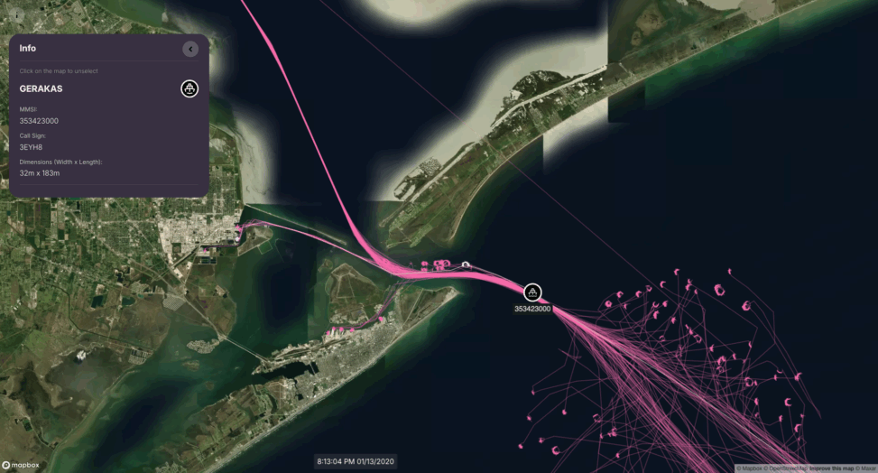
MapWeave integrates map, network, timeline and observations data into a unified, intuitive interface – empowering teams to build next-level solutions for complex geospatial intelligence challenges. With a pluggable architecture, scalable rendering, and a rich set of built-in tools, MapWeave makes it easy to integrate geospatial analysis into any intelligence application.
“MapWeave brings a level of clarity to geospatial investigations that simply hasn’t been available to our customers before,” said Dan Williams, Chief Product Officer at Cambridge Intelligence. “It helps organizations in security, fraud detection, and intelligence get more from their data – faster, and with fewer barriers.”
Solving the geospatial link analysis challenge
Traditional GIS tools show where things happen – but not why. MapWeave closes that gap, offering a purpose-built approach to understanding how people, objects, and events connect across time and space.
Whether tracking vehicle movements, identifying fraud rings, or mapping cyber threats, MapWeave helps users uncover hidden relationships that would otherwise remain buried in fragmented data systems.
From early access to enterprise-ready
Since launching its Early Access Program, Cambridge Intelligence has worked closely with users in multiple sectors to refine MapWeave for enterprise-ready deployments. The result is a robust, flexible SDK that enhances any investigation platform by bringing physical and digital data together in a single investigative view.
Key features of MapWeave Real-time performance across millions of data pointsTrajectory and movement analysis over timeSmart clustering and edge bundling for clear visual storytellingSmooth integration with Cambridge Intelligence’s KeyLines and KronoGraph SDKsExtensive documentation and demos to support fast development Discover next-level geospatial link analysis
MapWeave is now available to developers and organizations looking to enhance their geospatial intelligence workflows. To request a free trial, visit: https://cambridge-intelligence.com/mapweave/try/
About Cambridge Intelligence
Cambridge Intelligence has pioneered new ways to visualize complex data since 2011.
They help leading cybersecurity, intelligence and fraud detection organizations to power their applications with data visualization technology, so end users can uncover threats and reveal insights fast.
Distributed by https://pressat.co.uk/Business & Finance, Computing & Telecoms, Crypto Currency, Government, Manufacturing, Engineering & Energy, Medical & Pharmaceutical, Public Sector & Legal, Transport & LogisticsRead More
You might also be interested in reading How to buy gold with Bitcoin in 2025.